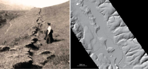
The San Andreas Fault takes its name from the eponymous reservoir that it crosses along the San Francisco Peninsula. The California Coast Range landscape owes much to the repeated deformation of earthquakes and subsequent landscape response. At 5:12 am on April 18, 1906 an earthquake rupture ripped along the San Andreas Fault from just offshore of the Golden Gate Bridge, southeast through the San Andreas Lake “rift valley” into the Santa Cruz Mountains. It also broke northwest through Bolinas and Tomales Bays. It continued along the seafloor and came back on shore tearing the ground past Fort Ross all the way to Manchester (just northeast of Point Arena). The shaking generated by the rupture was felt throughout northern and central California and the shock and after effects were devastating to San Francisco in particular.
The recent anniversary of the 1906 earthquake motivates reflection on the significance of the event, how our ability to anticipate such disasters has improved thanks to the work of geoscientists, and why federal support of science is a key part of improving understanding and ameliorating the effects of future events.
The scientific examination of the 1906 earthquake was a watershed in earthquake science. The detailed observations provided fodder for careful thinking about the movements before and during the earthquake, the propagation and strength of the shaking, and the effects on people and infrastructure. These observations and interpretations were presented in the report of the State Earthquake Investigation Commission on the California earthquake of April 18, 1906. The commission was headed by Andrew Lawson and included Henry Fielding Reid and Grove Karl Gilbert whose deductive perspective is pervasive in the document.
While it would be another half century until the interpretive paradigm of plate tectonics would provide some explanation as to the driving mechanism, it was clear from careful geodetic measurements that there was a long wavelength accumulation of elastic strains across the fault zone that were released abruptly in the earthquake (“elastic rebound” as explained by Reid in the Lawson report). Now, in the SF Bay area, there are more than 100 Global Positioning System receivers reporting their positions in real time with millimeter accuracy as part of the National Science Foundation-funded Plate Boundary Observatory. Numerous seismic stations operated by the US Geological Survey, UC Berkeley, Caltech, the state of California, and others record seismic waves for the region in real time too.
When the quake struck, Gilbert was woken up where he was staying in Berkeley. He later toured the fault zone in the Tomales-Bolinas area. He was impressed by the localization of the ground rupture. He also was convinced of the effect of repeated ruptures to build the distinctive rift valley topography along the fault zone. His notes about landforms and landscape evolution along the fault zone guide us today. Now we use lasers and photogrammetry from airborne and ground-based platforms to densely sample the topography along the San Andreas and other faults. These data are critical for indicating the effects of past ruptures and as an investment for differencing with future measurements after the next earthquake. We also make excavations across the fault traces and date densely sampled organic materials with radiocarbon to determine the recurrence rate of past earthquakes (now thought to be roughly a century with significant uncertainty).
Geoscientists (many employed by the USGS and the California Geological Survey, along with their academic colleagues) have built comprehensive models for future earthquakes building on the lessons from 1906. One of these, the landmark Uniform California Earthquake Rupture Forecast, required leadership and resources from responsible agencies as well as the efforts of a broad community of scientists and engineers.
On the occasion of the 1906 earthquake anniversary this year, the USGS released the Haywired Scenario. The hypothetical magnitude 7 earthquake along the Bay Area’s other scary fault―the Hayward―provides a powerful and tangible demonstration of what may happen in the event of a future earthquake. Prior to 1906, an earthquake along the Hayward fault in 1868 was called the “San Francisco Earthquake.” We are reminded that the Bay Area is astride the Pacific-North America Plate Boundary and the relative motion is accommodated by several seismogenic faults. Anticipating which will be activated next is extremely difficult. But we can forecast that earthquakes are expected.
The Bay Area metro region is notorious for its vast concentration of wealth due to the hard work and creativity of many people. Can they turn their attention at least partially to preparing themselves and their community to be resilient and outsmart the next disaster? Investments in seismological and geodetic resources to advance Earthquake Early Warning in California and the Pacific Northwest are a great help and measure of broad support to anticipate the effects of future earthquakes. Broad support for scientific investigations is essential. Public education and awareness to advance fundamental understanding of how the earth works as well as practical actions by individuals and communities to minimize the effects of future earthquakes is most important.