Earth Science and Human Activity: Taking Action to Avert Catastrophe
By Linda Rowan, AGU Societal Impacts and Policy Sciences (SIPS) Focus Group President, and Director of External Affairs, UNAVCO Inc.
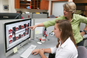
Intern Sarah Kittross and Linda Rowan (Photo Benjamin Gross/UNAVCO)
Earth science captures the public’s attention when a natural disaster strikes, when natural resources are needed or when Earth’s environment faces a threat. As the Earth science community prepares to celebrate Earth Science Week from 8-14 October 2017, with a theme of Earth Science and Human Activity, there has been significant catastrophic interaction between humans and Earth systems. A series of hurricanes in the Atlantic and Gulf of Mexico with direct hits on many Caribbean nations, the United States and Mexico; a couplet of earthquakes in southern Mexico with focused amplification in Mexico City; and the evacuation of thousands threatened by Agung volcano in Indonesia have caused the loss of lives, property, lifelines, and resources.
Recent natural disasters have led to many discussions about the extent that these disasters may have been human-caused or human-enhanced. Wildfires continue to rage across the western United States and statistics show that 84% of recent wildfires in the United States (from 1992 to 2012) were human-caused, with loss of life and property partly related to human choices at the urban-wildland interface. Increasingly, the paradox is that humans want to live and work close to nature, in forests and along shorelines where Earth systems can have direct impacts. Others want or need to live in large cities with known and recurring natural hazards. Watching people in Mexico City narrowly escape death or injury from falling concrete, falling glass panels or pancaking structures was terrifying. Human choices before, during and after an extreme event are also influenced by our confidence in infrastructure and our knowledge of Earth systems.
As growing populations interact with extremes in Earth systems, much can be done to mitigate the risk through understanding Earth science, informing human interactions with these systems, and improving confidence in infrastructure. It starts with basic research to understand Earth processes and this becomes the foundation for applied research and other societal benefits. Mexico has an earthquake early warning system that warned people in Mexico City about the shaking before it reached the metropolis. Florida improved their building codes after hurricane Andrew in 1992 and there was less wind damage to newer structures during the 2017 hurricanes.
It is imperative to advance our understanding of Earth systems, to inform policy, preparedness, forecasts, response and mitigation. It is imperative to bring this knowledge to the public because Earth science affects our daily lives and people need this knowledge to make choices about where and how they choose to live on this planet.
The United States Congress passed weather and tsunami legislation that became U.S. law in 2017. The legislation supports research and preparedness, forecasts, response and mitigation. In September of 2017, the National Earthquake Hazards Reduction Program (NEHRP) reauthorization was introduced in the Senate. NEHRP, which has existed since 1977, includes basic research through the National Science Foundation (NSF), applied research through the U.S. Geological Survey (USGS) and the National Institute of Standards and Technology (NIST), and preparedness and response through the Federal Emergency Management Agency (FEMA). Bringing multiple agencies together for a specific common cause, such as earthquake risk reduction, is one effective approach to enhance human-earth systems interactions.
My day job at UNAVCO revolves around geodesy. Geodesy is a global science involving the study of Earth’s size, shape, gravity and rotation. Geodesy has expanded its role in research with the growth of the Global Navigation Satellite Systems (GNSS), an Earth observing technology with many proven benefits. The U.S. Global Positioning System (GPS) is the largest and most established of many national systems that make-up the GNSS. GNSS allows for navigation and timing, which is fundamental for daily life. For basic research, GNSS defines the Earth reference system, precisely measures Earth surface motions, senses the dynamics of the atmosphere, and measures aspects of the cryosphere, hydrosphere and biosphere. Recently the International Union of Geodesy and Geophysics (IUGG) called for tsunami warning systems to be augmented with GNSS data. Although ground-based GNSS networks exist in many countries to provide real time data, much of the data is not accessible for tsunami early warning; thus the IUGG’s call for policy changes and data augmentation. This is another important way that humans can interact with Earth systems, by ensuring infrastructure supports society, and furthers our understanding of Earth science.
As president of AGU’s Societal Impacts and Policy Sciences (SIPS) focus group, I urge Earth scientists to seek ways to connect Earth science and policy for the benefit of Earth systems and human activity. Join SIPS, participate in Earth Science Week and work to connect your research and your applications to reduce the impacts of natural disasters, to effectively find and use natural resources, and to limit harm to Earth systems.
Im student of Earth Sciences from Mexico City, and I really loved this. Thank to show what is the role or Earth Sciences in our lives.